


Coastal zones are among the most dynamic and fragile environments on Earth, continuously shaped by waves, tides, currents, and human activity. In Indonesia, which has one of the longest coastlines in the world, shoreline change is a pressing issue that affects ecosystems, infrastructure, and communities. Pangandaran Regency in West Java is one such region, where Batu Hiu and Bojong Salawe beaches are experiencing noticeable shifts in their shoreline conditions.
This study by a team of researchers from Universitas Padjadjaran and collaborating institutions focuses on measuring and analyzing shoreline changes in Batu Hiu–Bojong Salawe between 2010 and 2019. The research aims to quantify rates of erosion and accretion and to provide scientific evidence for better-informed coastal management policies.
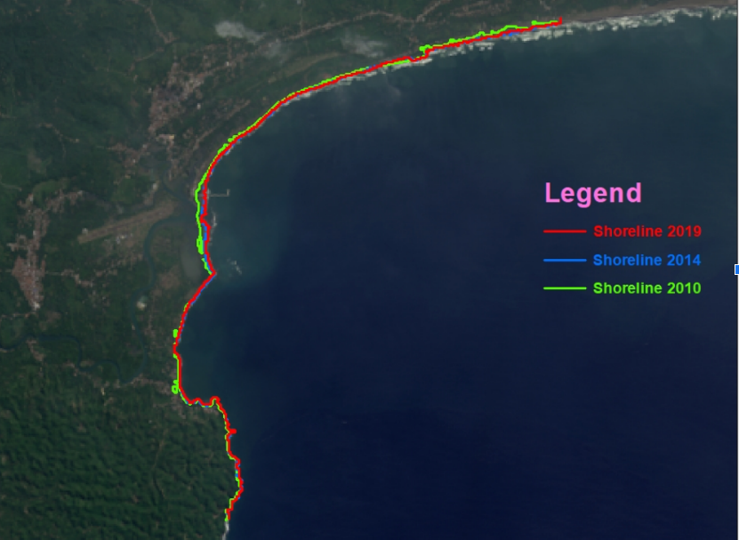
The team employed satellite imagery from Landsat 7 (2010) and Landsat 8 (2014 and 2019). These datasets were analyzed using ArcGIS and the Digital Shoreline Analysis System (DSAS), which enables precise measurements of shoreline movement. Three statistical methods were applied: Net Shoreline Movement (NSM) to track total displacement, Linear Regression Rate (LRR) to establish long-term trends, and End Point Rate (EPR) to calculate annual rates of change. A total of 160 transects were generated along the coastline to capture detailed patterns.
The results reveal contrasting dynamics across the region. At Batu Hiu, the western coast suffered significant erosion, with the shoreline retreating by nearly 30 meters at an average rate of about 3 meters per year. This was linked to the influence of rocky coastal formations that disrupt natural sediment flows. Conversely, Batu Hiu’s eastern coast showed clear accretion, with land extending by about 53 meters, and annual growth exceeding 5 meters per year.
At Bojong Salawe, accretion dominated. On average, the shoreline advanced by more than 83 meters, with annual growth rates of around 9 meters per year. The most dramatic gain was at one transect, where the shoreline expanded by over 134 meters. This growth was largely supported by sediment input from the Cijulang River estuary and the stabilizing effect of coastal groins. Only limited erosion occurred, affecting a few transects with far smaller losses compared to overall gains.
These findings show how natural factors like river estuaries and rock formations, combined with human-built structures such as groins, shape coastal dynamics in different ways. While erosion at Batu Hiu poses risks of land loss and potential threats to infrastructure, Bojong Salawe’s rapid accretion highlights the role of sediment supply in coastal growth. Both situations call for adaptive coastal management that balances protection, restoration, and sustainable development.
By combining remote sensing with DSAS, this research offers valuable insights for coastal policymakers, environmental managers, and local communities. It contributes directly to SDG 14 (Life Below Water) by supporting the sustainable management of marine and coastal ecosystems. At the same time, it connects to SDG 13 (Climate Action) through its relevance to climate-driven coastal risks and SDG 11 (Sustainable Cities and Communities) by highlighting the resilience of coastal settlements.
Meet the Researchers: This study was led by Subiyanto and colleagues from Universitas Padjadjaran, with collaboration from Universiti Sultan Zainal Abidin (Malaysia), Universiti Malaysia Terengganu, and Indonesia’s National Research and Innovation Agency (BRIN).
#UnpadResearch #CoastalManagement #SDG14 #LifeBelowWater #ClimateAction #SustainableCommunities #Pangandaran
Read the full paper here: https://www.scopus.com/pages/publications/85190807724
Journal of Advanced Research in Applied Sciences and Engineering Technology – Volume 42, Issue 2 (2024), pp. 58–71